| Home Page | Buying | Maps | Books | Prints | Ephemera |
- Home Page
- England & Wales County Maps Anglesea - Dorset
- England & Wales County Maps Durham - Merioneth
- England & Wales County Maps Midd'x - Somerset
- England & Wales County Maps Staffs - Yorks
- British Isles: Physical, Railways, Statistical, etc. Roman Britain
- England & Wales, Countries, Islands, Regions inc. the Lake District, Road & Rail Maps
- Scotland, the Country & Regions: Town Plans & Environs; Rail Maps
- Ireland, the Country, Regions & Environs
- England & Wales, Town Plans & Maps of Environs
- Ordnance Survey and Folding Maps
There are 10 pages of maps of the British Isles. Please see the index on the Great Britain page to gain access to 1000 maps of England, Wales, Scotland and Ireland.
All our maps are Originals, NOT modern reproductions and have thumbnails as well as larger images so it is easy to find what you are looking for.
If you want several items, email me for a discount!
Email: don@theoldmapman.com
> Section 1 > Section 2 > Section 3
 Northamptonshire & Northumberland John Cary 1792 - 10.5 x 16 cm Antique double sided maps from The Traveller's Companion, with original fine hand colouring of boundaries, roads, towns & parks. Larger image 1 : Larger Image 2 Ref uk1844 : £16 Return to Great Britain & Ireland Index |
 Northamptonshire, North G W Bacon 1887 - 46 x 31 cm Large double page hand coloured map as issued with woods, parks, hills, roads and railways. The railway companies are named on each line. A very short repair on the front with transparent water based tape at the very foot of the centrefold and strengthening behind at top and bottom. Larger image Ref uk509 : £5 Return to Great Britain & Ireland Index |
 Northamptonshire, North G W Bacon 1897 - 46 x 31 cm Large double page coloured map with woods, parks, hills, roads and railways. The railway companies are named on each line. A very nice copy. Larger image Ref uk511 : £6 Return to Great Britain & Ireland Index |
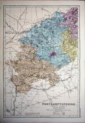
 Northamptonshire, North G W Bacon 1898 - 46 x 31 cm Large double page coloured map with woods, parks, hills, roads and railways. The railway companies are named on each line. A little foxing around edges. Larger image Ref uk512 : £5 Return to Great Britain & Ireland Index |
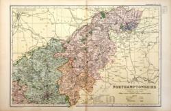
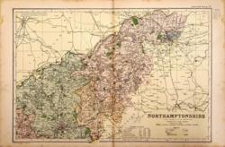
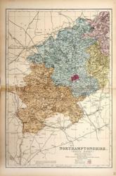
 Northamptonshire, North G W Bacon c 1885 - 46 x 31 cm Large double page hand coloured map as issued showing woods, parks, hills, roads and railways together with towns, villages and hamlets and even individual properties. The railway network is very clearly shown and the railway companies are named on each line. A very attractive map in fine condition. Larger image Ref uk948 : £12 Return to Great Britain & Ireland Index |
 Northamptonshire, South G W Bacon 1887 - 31 x 46 cm Large double page hand coloured map as issued with woods, parks, hills, roads and railways. The railway companies are named on each line. Has been repaired on the front with transparent water based tape at the LHS of the centrefold, for 2 or 3 cm. Larger image Ref uk513 : £3 Return to Great Britain & Ireland Index |
 Northamptonshire, South G W Bacon 1897 - 31 x 46 cm Large double page coloured map with woods, parks, hills, roads and railways. The railway companies are named on each line. Has a strengthened or repaired centrefold. Larger image Ref uk515 : £6 Return to Great Britain & Ireland Index |
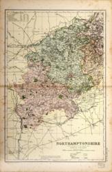 Northamptonshire, South G W Bacon 1898 - 31 x 46 cm Large double page coloured map with woods, parks, hills, roads and railways. The railway companies are named on each line. Some foxing around edges but will look fine in a mount. Larger image Ref uk516 : £5 Return to Great Britain & Ireland Index |
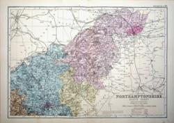
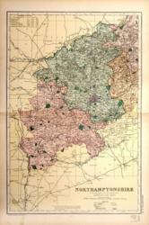
 Northamptonshire, South G W Bacon c 1885 - 31 x 46 cm Large double page hand coloured map as issued showing woods, parks, hills, roads and railways together with towns, villages and hamlets and even individual properties. The railway network is very clearly shown and the railway companies are named on each line. A very attractive map in fine condition. Larger image Ref uk949 : £12 Return to Great Britain & Ireland Index |
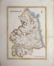
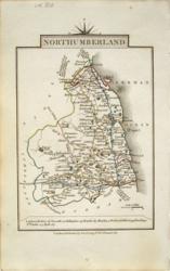
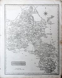
 Northumberland G & W B Whittaker 1824 - 11 x 18 cm Uncoloured detailed map in which is laid down every Parish & Place containing upwards of 40 houses; table of information on the county. A few spots. Larger image Ref uk031 : £8 Return to Great Britain & Ireland Index |
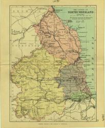 Northumberland Geo. Philip & Son 1889 - 15 x 21 cm Printed colour hundreds. Large number of railway lines. Larger image Ref uk099 : £7 Return to Great Britain & Ireland Index |
 Northumberland Hughes for Virtue & Co. 1868 - 24 x 32 cm Colour printed map of the county showing roads and railways. The Divisions in different colours. A trifle grubby. Larger image Ref uk434 : £4 Return to Great Britain & Ireland Index |
 Northumberland Hughes for Virtue & Co. 1868 - 24 x 32 cm Colour printed map of the county showing roads and railways. Larger image Ref uk435 : £5 Return to Great Britain & Ireland Index |
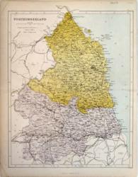
 Northumberland J & C Walker 1850 - 23 x 31 cm Hand-coloured map with roads in red and mountains in brown. For Lewis' Topographical Dictionary. Very nice map. Larger image Ref uk214 : £24 Return to Great Britain & Ireland Index |
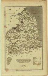
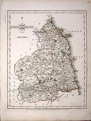 Northumberland John Cary 1787 - 21 x 27 cm Antique map with original hand colouring of roads, woodland and the county boundaries. Faint marks at lower right. Supplied with a separate sheet describing the county and its industry, farming, gentry and environment, together with a list of the country seats and The most remarkable Places for extensive Prospects, etc. Larger image Ref uk1295 : £26 Return to Great Britain & Ireland Index |
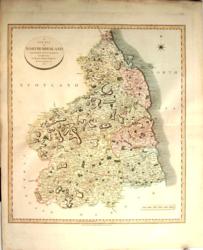 Northumberland John Cary 1801/11 - 48 x 54 cm Very fine hand wash colouring with roads, etc., finely coloured. Full wide margins all round Larger image Ref uk167 : £45 Return to Great Britain & Ireland Index |
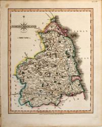 Northumberland John Cary 1821 - 21 x 27 cm The very finest quality original hand colouring of roads, woodland and the county boundaries. Supplied with a separate sheet describing the county and its industry, farming, gentry and environment, together with a list of the country seats and The most remarkable Places for extensive Prospects, etc. Larger image Ref uk277 : £28 Return to Great Britain & Ireland Index |
 Northumberland John Cary 1822 - 9 x 14 cm Original hand colouring of roads, woodland and the county boundaries. Larger image Ref uk813 : £16 Return to Great Britain & Ireland Index |
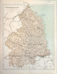
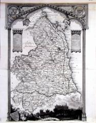 Northumberland Thomas Moule c1845 - 28 x 22 cm Decorative map with vignettes and coats of arms. Uncoloured as issued. As is often the case with these maps there are several original folds and the engraving reaches edges of the sheet (In fact part of the name of the county has been lost), where old paper extensions will make fitting it to a mount easier. Several railways are shown. Larger image Ref uk1063 : £10 Return to Great Britain & Ireland Index |
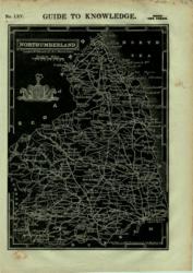 Northumberland W Edwards 1833 - 23 x 17 cm White on Black with Coat of Arms From Guide to Knowledge. With Coat of Arms. Larger image Ref uk010 : £6 Return to Great Britain & Ireland Index |
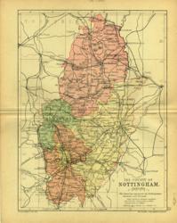
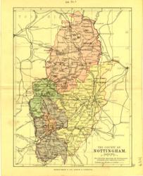
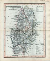 Nottinghamshire Archer for Dugdale 1850 - 18 x 24 cm Very fine outline hand colouring of the County and Hundred boundaries as well as the railways which are a feature of these attractive maps Larger image Ref uk325 : £8 Return to Great Britain & Ireland Index |
 Nottinghamshire Geo. Philip & Son 1890 - 15 x 21 cm Printed colour hundreds. Large number of railway lines. Larger image Ref uk100 : £7 Return to Great Britain & Ireland Index |
 Nottinghamshire Geo. Philip & Son 1889 - 15 x 21 cm Printed colour hundreds. Large number of railway lines. Larger image Ref uk101 : £7 Return to Great Britain & Ireland Index |
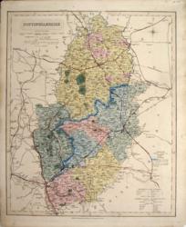 Nottinghamshire J & C Walker 1836 - 32 x 39 cm Original wash hand-colouring of the Divisions, Hundreds and Boroughs. A fine map. Larger image Ref uk187 : £26 Return to Great Britain & Ireland Index |
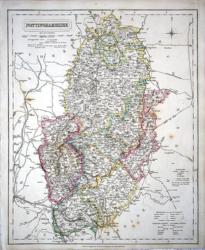 Nottinghamshire J & C Walker 1837 - 32 x 39 cm Fine original hand colouring of the hundreds and the county boundaries. Offered at reduced price because of a few spots of foxing. (See image). Shows the Midland Counties Railroad and the North Midland to Leeds. Larger image Ref uk855 : £17 Return to Great Britain & Ireland Index |
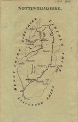 Nottinghamshire John Aikin 1809 - 10 x 15 cm Simple map showing county outline, rivers and some towns Larger image Ref uk021 : £7 Return to Great Britain & Ireland Index |
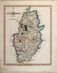
 Nottinghamshire John Cary 1787 - 21 x 27 cm Antique map with original hand colouring of roads, woodland and the county boundaries. One margin is narrow and there is a smudge in the lower left corner of the margin, (see image). Supplied with a separate sheet describing the county and its industry, farming, gentry and environment, together with a list of the country seats and The most remarkable Places for extensive Prospects, etc. Larger image Ref uk1296 : £24 Return to Great Britain & Ireland Index |
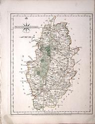
 Nottinghamshire John Cary 1821 - 21 x 27 cm The very finest quality original hand colouring of roads, woodland and the county boundaries. Supplied with a separate sheet describing the county and its industry, farming, gentry and environment, together with a list of the country seats and The most remarkable Places for extensive Prospects, etc. Larger image Ref uk278 : £28 Return to Great Britain & Ireland Index |
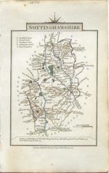 Nottinghamshire John Cary 1822 - 9 x 14 cm Original hand colouring of roads, woodland and the county boundaries. Slight toning around the margins. Larger image Ref uk814 : £14 Return to Great Britain & Ireland Index |
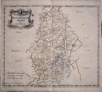 Nottinghamshire Robert Morden 1695/1772 - 41 x 34 cm Uncoloured copy of this map is in very good condition and which has ample margins. Larger image Ref uk1132 : £55 Return to Great Britain & Ireland Index |
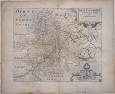 Nottinghamshire Saxton/Kip c1637 - 31 x 26 cm Uncoloured map with wide margins and in the third state. There is a slight toning on part of the centre fold but this is less noticeable than it appears in the image. Larger image 1 : Larger Image 2 Ref uk1131 : £95 Return to Great Britain & Ireland Index |
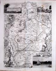 Nottinghamshire Thomas Moule c1845 - 28 x 22 cm Decorative map with vignettes and coats of arms. Uncoloured as issued. As is often the case with these maps there are several original folds. Several railways are shown. Larger image Ref uk1064 : £12 Return to Great Britain & Ireland Index |
 Nottinghamshire & Oxfordshire John Cary 1792 - 10.5 x 16 cm Antique double sided maps from The Traveller's Companion, with original fine hand colouring of boundaries, roads, towns & parks. Larger image 1 : Larger Image 2 Ref uk1845 : £20 Return to Great Britain & Ireland Index |
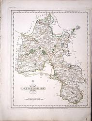 Oxfordshire John Cary 1787 - 21 x 27 cm Antique map with original hand colouring of roads, woodland and the county boundaries. One margin is very narrow, (see image). Supplied with a separate sheet describing the county and its industry, farming, gentry and environment, together with a list of the country seats and The most remarkable Places for extensive Prospects, etc. Larger image Ref uk1297 : £24 Return to Great Britain & Ireland Index |
 Oxfordshire Neele sculp't, Strand. Published by J. Robins & Co. Albion Press, London, January 1st 1818. 1818 - 19.5 x 25 cm Original antique engraved map. Larger image Ref uk1776 : £9 Return to Great Britain & Ireland Index |
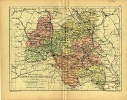 Oxfordshire & Bucks Geo. Philip & Son 1890 - 20 x 15 cm Printed colour hundreds. Large number of railway lines. Larger image Ref uk102 : £6 Return to Great Britain & Ireland Index |
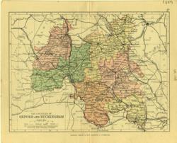 Oxfordshire & Bucks Geo. Philip & Son 1889 - 20 x 15 cm Printed colour hundreds. Large number of railway lines. Larger image Ref uk103 : £6 Return to Great Britain & Ireland Index |
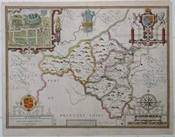 Radnor John Speede 1611-27 - 51 x 38.5 cm Sold by Sudbury & Humbell. Hand colouring old but unlikely to be contemporaneous with the printing. A very strong impression giving rise to my view that it is an early issue. A strengthening of the lower margin near the centrefold. The text verso was heavily pressed and the indentations can be felt on the front. 530 x 420 mm overall. Otherwise very good condition. Larger image 1 : Larger Image 2 : Larger Image 3 : Larger Image 4 Ref uk1682 : £190 Return to Great Britain & Ireland Index |
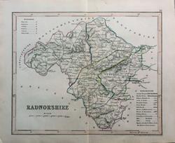 Radnorshire Drawn & engraved by J. Archer, Pentonville, London. c1850 - 23 x 18 cm Very fine original outline hand colouring of the County and Hundred boundaries as well as the railways which are a feature of these attractive maps. Centrefold as issued. Larger image Ref uk1647 : £8 Return to Great Britain & Ireland Index |
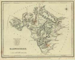 Radnorshire J & C Walker / Lewis 1842 - 23 x 18 cm Uncoloured map. Narrow margins. Larger image Ref uk372 : £4 Return to Great Britain & Ireland Index |
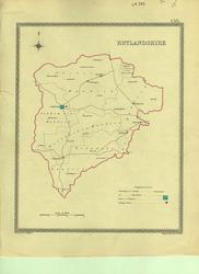 Rutland Creighton; J&C Walker 1835 - 18 x 23 cm Parliamentary boundary map showing polling places and Borough Towns with the number of members to be returned from each. County and electoral boundaries shown in original outline hand colouring. Larger image Ref uk383 : £7 Return to Great Britain & Ireland Index |
 Rutland John Cary 1787 - 27 x 21 cm Antique map with original hand colouring of roads, woodland and the county boundaries. Margins a little dusty and a little light foxing at the top. Supplied with a separate sheet describing the county and its industry, farming, gentry and environment, together with a list of the country seats and The most remarkable Places for extensive Prospects, etc. Larger image Ref uk1298 : £20 Return to Great Britain & Ireland Index |
 Rutland & Shropshire John Cary 1792 - 10.5 x 16 cm Antique double sided maps from The Traveller's Companion, with original fine hand colouring of boundaries, roads, towns & parks. Larger image 1 : Larger Image 2 Ref uk1846 : £14 Return to Great Britain & Ireland Index |
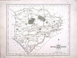
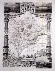 Rutlandshire Thomas Moule c1845 - 28 x 22 cm Decorative map with vignettes and coats of arms. Uncoloured as issued. As is often the case with these maps there are several original folds. Some light foxing along folds (see image). Several railways are shown. Larger image Ref uk1066 : £9 Return to Great Britain & Ireland Index |
 Shropshire Creighton; J&C Walker 1835 - 19 x 24 cm Parliamentary boundary map showing polling places and Borough Towns with the number of members to be returned from each. County and electoral boundaries shown in original outline hand colouring. Larger image Ref uk385 : £8 Return to Great Britain & Ireland Index |
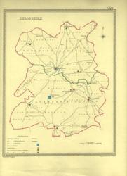
 Shropshire Geo. Philip & Son 1889 - 15 x 21 cm Printed colour hundreds. Large number of railway lines. Larger image Ref uk104 : £7 Return to Great Britain & Ireland Index |
 Shropshire Geo. Philip & Son 1890 - 15 x 21 cm Printed colour hundreds. Large number of railway lines. Larger image Ref uk105 : £7 Return to Great Britain & Ireland Index |
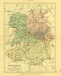
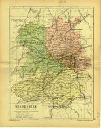
 Shropshire Hughes for Virtue & Co. 1868 - 24 x 31 cm Colour printed map of the county showing roads and railways. The Divisions in different colours. Short marginal repairs. Larger image Ref uk436 : £5 Return to Great Britain & Ireland Index |
> Section 1 > Section 2 > Section 3 | |||